


Published on the 25/09/2024 | Written by Heather Wright
PGG Wrightson’s Skycount takes to the air…
Agricultural services provider PGG Wrightson has taken to the sky – and AI – to count sheep (and cows), improving speed, accuracy and efficiency in the process.
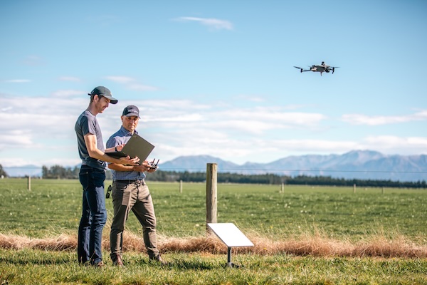
Skycount, which was showcased at Mystery Creek Fieldays earlier this year and has now launched commercially, integrates aerial imagery and AI software to conduct livestock audits. Footage captured by DJI drones using HD cameras is analysed by an advanced AI model designed to identify and count specific species, including cattle and sheep, across diverse farm landscapes and conditions.
“I’m hopeful that within another few years, we’ll have another 20 benefits we don’t even know about yet.”
The technology slashes the count time and improves accuracy and efficiency for counts which are required for audit and insurance purposes.
Rounding up and bringing in animals for a count is logistically demanding and can take up to a week for large properties with multiple mobs of sheep or cattle – dairy herds range from 200 to 2,000 animals. It also increases the risk of injuries and stress to animals and farm workers, while taking them away from regular farming operations.
Skycount can conduct accurate counts on a herd or flock ‘within minutes’, with farmers able to review and approve the results in a few minutes.
Getting numbers right is essential with animals worth up to $20,000 a head, says Roger Lamb, PGG Wrightson national operations manager, livestock.
“In today’s environment, farmers are counting every penny, so every animal that’s missing is a big hole in your books,” he says.
While the farm supplier, which commissions stock agents to audit counts, was keen to harness drones and AI-powered stock counts, Lamb says existing solutions didn’t meet their needs. So the company partnered with Kiwi enterprise IT and cloud specialist Inde Technology to develop its own offering.
A range of drones were considered for the project, but while larger drones could carry bigger cameras, they also posed issues with flight planning – flying them near controlled airspace requires permission from the Civil Aviation Authority. Smaller drones, on the other hand, needed to fly too low and could frighten animals. Dairy cattle in particular didn’t like the sound of drones.
The cameras also provided a challenge. Initial use of infrared cameras found they couldn’t ‘see’ the sheep through their thick fleece. Still cameras required photos to be stitched together and resulted in blurry images and made it easier to lose or duplicate animals.
DJI Mavic Enterprise Series drones shooting regular video via HD cameras were ultimately selected.
Meanwhile tens of thousands of images were captured and processed in Microsoft Azure to train the AI model.
Rik Roberts, Inde chief technology officer, says ‘countless’ hours were spent collecting high-quality aerial images to feed the model, including characteristics of different breeds and photographing them in a range of environments at different times of the day to ensure shadows, trees and rocks weren’t mistaken to animals and vice versa.
“There’s a lot of variability in landscape types between regions and animal breeds,” Roberts says. “Getting enough data was the real challenge, including grass types, terrain types and weather conditions.”
Large open-country farms also provided their own challenges, Roberts says. Unlike narrow dairy farm paddocks, they required ‘a different approach’.
“Combining trigonometry, physics and drone technology to track each detected animal across multiple images, we’ve minimised the risk of double or missed counts.”
Inde also recompiled the object detection model for the NPUs (Neural Processing Units) found on Apple MacBooks and Copilot+ PC chipsets, to process video on real-time.
“This capability not only provides immediate value to farmers by reducing administrative and monitoring time, but also offers PGG Wrightson and the livestock team critical data for better forecasting of inventory and making more accurate decisions regarding crop and herd management,” Roberts says.
Finalised counts, with accuracy of around 97 percent first time, are submitted to SkyCount, which uses Microsoft Power Apps to combine the farms information with the count and generate an audit report.
Automated mission planning for the drones, which often operate in remote rural areas with limited connectivity, was also established to enable the drones to execute flight plans consistently and efficiently.
“If the property does not already have a digital map, we’ll do an initial mapping mission,” Roberts says.
Flight altitudes, directions and angles of the cameras are defined so the drone will fly the same mission each time it is sent out.
An early trial of the technology identified livestock in a paddock which the farmer believed had no stock in it.
Lamb says SkyCount enables PGG Wrightson to do audits without moving a single animal or interrupting farmers’ operations.
“We can come and do our thing, and the people on the farm don’t necessarily know we’ve even been there. This is a significant time reduction, allowing staff on the farm to do other work,” he says.
Lamb says PGG Wrightson is now investigating ways to integrate IoT devices and farm management software to create a comprehensive, automated system for monitoring and managing operations.
“As for SkyCount, I’m hopeful that within another few years, we’ll have another 20 benefits we don’t even know about yet.”