


Published on the 05/03/2026 | Written by Heather Wright
Big challenges, bigger national gains that go beyond agri…
Professor Andy Koronios is clearly energised about Australia’s $15 million National Agricultural Digital Twin. He describes the platform as potentially ‘transformational’ – a long awaited breakthrough that will provide a real-time, integrated view of Australia’s entire agricultural, forestry and fisheries landscape through unifying satellite observations, weather systems, soil data and farm-level information into a single, national intelligence system.
“Once these foundations are established, the lessons learned – both technical and institutional – can be applied to other sectors.”
Koronios, founding CEO and managing director of the Australasian Space Innovation Institute (ASII), says the digital twin, launched last month and a flagship initiative for ASII, isn’t just another farm app or dashboard, it’s a chance to rewrite how a climate-exposed, globally competitive sector makes decisions, replacing delayed, fragmented information with AI-enabled ‘what if’ scenario modelling across climate resilience, biosecurity, water management and productivity, enabling decision-makers to test options, anticipate risks and optimise actions before implantation.
And the benefits won’t just be reaped by the agricultural sector with Koronios telling iStart the initiative will establish a national capability in digital twin infrastructure and space-enabled intelligence, which can progressively support multiple sectors of the economy.
“Agriculture provides an ideal first application because it allows us to develop the core architecture, governance frameworks and data integration methods that are necessary for large-scale digital twins. Once these foundations are established, the lessons learned – both technical and institutional – can be applied to other sectors.”
He says the same principles used to integrate satellite observations, environmental data and modelling tools for agriculture could also support digital twins for water systems, natural ecosystems, coastal environments or disaster management.
Real-time national picture
The elevator pitch is simple – but bold: Bring satellite earth observation data, sensors, climate records, soils, agronomic models and the wealth of other data already available into a single sovereign, AI-enabled system that mirrors conditions on the ground and updates continuously. The digital twin aims to end the fragmentation that has existed in agriculture and turn the abundance of data into decision-ready intelligence that can be used with confidence.
For Meat and Livestock Australia, who along with Elders and Charles Sturt University are backing the initiative, the prize is speed and certainty. Michael Lee, Meat and Livestock Australia’s group manager for science and innovation, told iStart the twin could ultimately reduce risk and potentially cut years from research cycles.
By putting hypotheses through a virtual R&D engine first, teams can refine and narrow failure modes, deploying only what looks likely to work. Producers, in turn, could see more accurate grazing plans, better timed interventions and lower operating risk, with the potential to also unlock provisions for stronger evidence for sustainability and traceability requirements – something brand owners could be rewarded for in a margin-tight industry, where proof that travels cleanly through the value chain is money.
“We are expecting that the digital twin will support evidence-based scenario testing by combining satellite imagery, climate data and agri models in one system. Industry can use this to then compare stocking plans, pasture strategies or herd timing against various climate outlooks and assess expected changes in productivity, groundcover and emissions intensity.”
This supports the kind of repeatable and transparent assessments needed by producers, researchers and other supply chain partners, which could even include banks and other policy advisors who are looking for analytical intel on how agriculture is performing and where it is heading, he says.
Lee has a long list of use cases that most excite him. Top of the list is forecasting pasture growth and testing grazing strategies under different seasons. Climate and drought scenario planning supporting early and confident decisions; landscape pest, weeds and biosecurity modelling for coordinated responses; testing water and infrastructure options for improved productivity and animal welfare and emissions and natural capital modelling using satellite data and agronomic models also feature.
Koronios has a similar list, with the addition of carbon and sustainability monitoring. “As global markets increasingly demand proof of sustainable farming practices, the digital twin could help measure land condition, vegetation cover and carbon outcomes across farms, giving Australian producers a credible way to demonstrate environmental stewardship,” he says.
“What excites me most is that these applications are not futuristic concepts. The underlying technologies already exist. The digital twin simply brings them together into a single intelligence platform that helps farmers make better decisions every day.”
Phased, with challenges…
The program will be delivered in a phased development approach, with Koronios stressing that practical benefits will be realised progressively, rather than only at the end of the program.
First up is the formal establishment of the program’s governance structure, including a steering committee and key delivery partnerships. Koronios says initial workstreams will focus on designing and building the core digital twin platform while working with industry and research partners to validate the first practical use cases.
“During this phase the emphasis will be on developing and testing the foundational capabilities: Integrating key data layers, building analytical tools, and demonstrating how the system can support real-world agricultural decision-making,” he says.
Importantly, early pilot deployments will allow farmers, agronomists, industry partners and government agencies to begin using and benefiting from the platform as it evolves, rather than waiting for a fully completed system. Koronois says these early deployments will provide immediate value while also helping refine the models through real-world feedback.
As the platform matures, the program will expand from pilot deployments to nationally scalable operational services, incorporating additional datasets, analytical models and regional applications. With each phase, new capabilities and insights will become available to users, expanding the value.
“Ultimately, the National Digital Twin for Australian Agriculture is conceived as a long-term national capability – a digital infrastructure designed to support Australia’s agricultural sector for decades to come. Much like national mapping systems or weather forecasting networks, it will act as a shared digital backbone for agricultural intelligence, supporting productivity, climate resilience, biosecurity and evidence-based policy.”
There are, of course, technical challenges, the biggest of which will be bringing together all the agricultural, environmental and satellite data sets into a single, consistent system that can operate across an entire continent.
Koronios notes currently data, models and insights remain fragmented across jurisdictions, research programs, Research and Development Corporations and proprietary platforms. “This fragmentation has resulted in duplication, inconsistent standards, slow translation of research into practice and rising costs for levy payers and taxpayers alike.”
Each of the datasets, which come from a wide range of sources including satellites, weather systems, soil databases, farm sensors and government programs – has different formats, resolutions and update cycles. Harmonising those datasets so they can be combined into a coherent, real-time model will be no mean feat.
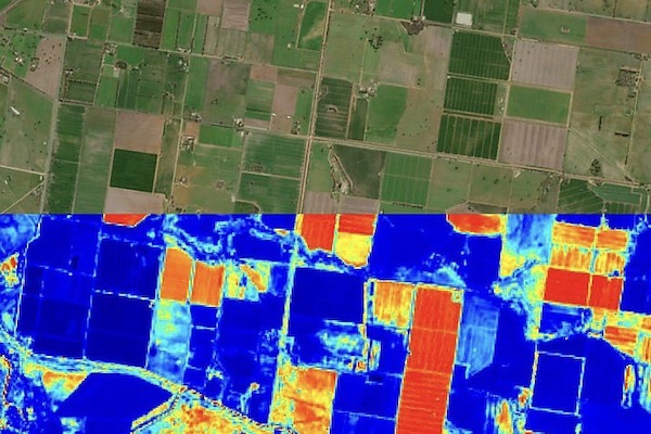
One of the most important layers is the satellite earth observation data, which provides frequent updates on vegetation health, crop growth, pasture condition and land use across the entire country, every few days and in a few cases as frequently as daily. “This gives us a consistent, continent-wide view that simply isn’t possible from ground observations alone,” Koronios says.
Soil and moisture data will be another critical layer, helping farmers and advisors understand water availability and plant stress. When combined with weather and climate data it becomes possible to anticipate drought conditions, irrigation needs and crop development patterns.
Farm-level and environmental data, such as sensor measurements, land management information and water systems will also be integrated, providing the local detail needed to translate satellite observations into meaningful insights for individual farms.
Biosecurity and environmental monitoring datasets will also be included, helping detect changes in vegetation patterns that could signal pests, disease outbreaks or land degradation.
“The real value comes from combining these layers, because when they are analysed together they reveal patterns and trends that would not be visible in any single dataset,” Koronios says. “This is a current gap in the ecosystem.”
Scale is another challenge, Koronois is preparing for, with Australia’s agricultural regions spanning millions of square kilometres. “The system must process very large volumes of data continuously, while still delivering useful insights at the level of individual farms or paddocks.”
He says modern cloud computing, AI and advanced observations will address those issues to integrate and interpret data streams. “Rather than trying to centralise everything in one system, the digital twin works as an intelligent platform that connects existing systems and continuously updates the model as new data arrives.”
The final challenge is ensuring information is practical and usable for farmers and advisors, not just technically sophisticated, he says. That means designing tools and dashboards that translate complex data into clear insights that support real-world decisions.
“We are embarking on a journey where the priority is not the volume of data, but the acceleration of technology adoption. We want to ensure that the data we ingest translates into high-value insights and practical tools that the industry can trust and use with ease. The Digital Twin will work by integrating multiple layers of data that together describe what is happening across Australia’s agricultural landscape.”
Over time other information sources will be integrated, particularly as Australia’s sovereign earth observation capabilities advance and tech such as IoT networks with intelligent sensors are increasingly deployed across agriculture and related sectors.
“Ultimately, the Digital Twin is not a destination with a fixed finish line. It is a living R&D engine designed for continuous progress and evolution. There is no ideal amount of data, as the system is designed to learn and improve as we move forward.”
There’s a broader national dividend here, too. A sovereign digital capability for agriculture is a food‑security asset as much as it is a productivity play. It reduces reliance on offshore analytics to interpret Australia’s land and climate signals, while creating a platform for local companies and researchers to build exportable services on top. In Koronios’s framing, the twin strengthens food systems and regional economies today while laying tracks for tomorrow’s cross‑sector twins – water systems, disaster resilience, coastal environments – a reusing the architecture and governance patterns forged in agriculture.
Koronios says in practical terms the twin is designed as an open, modular platform that different users will interact with in ways that suit their needs. For agronomists and advisors, the most common interface will likely be intuitive dashboards and decision-support tools that translate complex datasets, such as satellite observations, soil moisture and weather data, into clear insights about crop health, risk conditions and management options. For agtech companies and software developers, the platform will provide APIs that allow them to integrate digital twin data directly into their own applications and farm management systems. “This means companies can build specialised tools, such as irrigation optimisation models, yield forecasting systems or sustainability monitoring platforms, using the digital twin as the underlying intelligence layer.”
Researchers and advanced users will also be able to access modelling environments and analytical tools to develop new algorithms, predictive models and agronomic insights.
“The platform is not intended to be a closed system controlled by a single organisation. Instead, it is conceived as a national innovation platform that allows multiple organisations – agtech companies, research groups, industry bodies and government agencies – to build services and applications on top of the core infrastructure.
“In that sense, the digital twin acts as a shared intelligence layer for agriculture, enabling an ecosystem of tools and innovations to emerge around it, while ensuring that the underlying data and analytical capabilities remain consistent, trusted and nationally coordinated,” Koronios says.
“If we get this right, the Ddigital twin will become something that future generations of farmers simply take for granted – much like weather forecasting or satellite navigation today – because it supports better decisions across the entire agricultural sector.”