


Published on the 23/08/2018 | Written by Heather Wright
Some interesting uses of GIS, storytelling winners and a new aerial imagery option…
This week’s New Zealand Esri User Conference gave us the chance to peek behind the scenes and see what Kiwi organisations are doing with GIS.
Three interesting uses of GIS
From providing an enhanced view of water allocation in Northland, to providing data on erosion risk so farms can prioritise issues and actions on-farm, GIS is being used around New Zealand to enhance businesses and help communities.
- Wellington Graffiti Management Hub
Wellington City Council has removed more than 62,000 tags – or 76,000m2 of tagging – since 2015 with the council spending $570,000 per year on removal costs. The Wellington Community Services Graffiti Manager is a GIS tool used to explore, understand and respond to graffiti in Wellington. Jonathan Moore, GIS advisor for Wellington City Council community services, says the Graffiti Manager simplifies complex datasets into easy-to-understand visualisations and provides insights into how Wellington communities are being affected by graffiti while also measuring the impacts of community interventions. Even more importantly, he says, the system transforms the traditional workflow of creating periodic reports and provide detailed, comprehensive reports at users fingertips, anywhere anytime.
- Improving fertiliser – and environmental – outcomes on high country farms
Ravensdown, in conjunction with Massey University and AgResearch, with funding from MPI, is using remote sensing of soil fertility to create variable rate fertiliser plans for precision aerial application. The initiative, currently being trialed at seven farms, has an aim of providing greater production and profitability with less nutrient wastage, and will also help avoid applying fertiliser to areas such as bush.
Remote scanning of the land from a small plane combined with algorithms produces soil fertility maps which are integrated with other maps from a farm to produce a fertiliser plan, detailing the right quantities of fertiliser for each area, which is uploaded to a computer in the plane delivering the fertiliser.
- Mapping NZ
A 10 year programme is seeing Land Information New Zealand mapping New Zealand – from Aoraki/Mount Cook to the edge of the continental shelf, with a view providing information for better decision making on challenges facing the country including climate change and urban growth.
“It simplifies complex datasets into easy-to-understand visualisations and provides insights.”
Linz’s Graeme Blick notes that land is just one part of the mapping project. “Looking at New Zealand from the land perspective is just the tip of the iceberg. To put it into context… we’re looking at mapping in the area about the size of Australia.”
So why bother with the mapping? “There are some really key challenges New Zealand is facing. For example it is said that half the infrastructure that will be needed by 2050 hasn’t been built yet. This government is talking about planting a billion trees. We know we are going to suffer the impacts of climate change and other pressures on New Zealand so there are some real challenges for us.
“We want the data to be used to answer some of those questions. Where are we going to plant one billion trees, over a million hectares worth of trees? Where are we going to build a half million buildings required in Auckland over the next 30-50 years? Where do we need to minimise the impacts of flooding?”
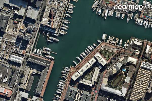
Nearmap launches Kiwi operations
Australian aerial imagery provider Nearmap launched it’s assault on the local market, taking to the Esri User Conference to highlight it’s offering which provides high resolution (7.5cm GSD or higher) aerial maps of 14 major urban and regional centres.
The company is targeting Kiwi businesses in construction, engineering, architecture, utilities, government, council and beyond, for its cloud-based subscription service. Measurement tools such as line, area and radius, as well as location data content is included, with the imagery able to be integrated into applications such as ArcGIS Online and CAD.
Rob Newman, Nearmap CEO and managing director, cites the example of a construction company needing to assess a new build site, or a solar panel installer wanting to quote for a job. “Nearmap lets you do all of that without having to leave your desk. This allows businesses to redirect time and money to the most important business priorities.”
Stephen Neale, Nearmap presales engineer, says because access is via a web browser it opens up possibilities for non-technical users, with roofers and solar panel installers using Nearmap to quote without having to do site visits.
“You don’t need to be a GIS user to benefit from imagery,” says Kevin Kwok, Nearmap technical product manager. “That’s a game changer because traditionally you needed the right software, the right skills, large amounts of storage for your imagery. Now you can go online and use the imagery on your terms, paying for what you use.”
The company says it will be covering New Zealand at least once a year, if not twice, with its cameras fitted to aircraft, to ensure up to date imagery. More than 1,000km2 can be captured per day.
Nearmap was founded in Australia 10 years ago and also has operations in the United States. Its Aussie customers include Telstra, Optus and Downer.
Three winning ‘story maps’
The conference also saw three companies recognised for their storytelling with maps. Members of the GIS community were asked to create New Zealand’s best Story Map on whatever subject they wanted, with the winner heading to San Deigo for the 2019 Esri UC.
An story map, telling the story of Malaysia Airlines Flight 17 and its aftermath was the overall winner, with judges noting it told a good story with multiple maps each with a focus and a good balance of maps and other visuals.
Wellington Botanic Gardens and the Otakaro Avon River Corridor Exhibition, detailing the impact of the Canterbury earthquakes on the region and the regeneration plans, were finalists.
Image courtesy of Nearmap.